Tayloe House Historical Report, Block 28 Building 3 Lot 262,Originally entitled: "Tayloe House (Block 28 Colonial Lot 262) 1949"
Colonial Williamsburg Foundation Library Research Report Series - 1523
Colonial Williamsburg Foundation Library
Williamsburg, Virginia
1990
TAYLOE HOUSE
(Block 28 Colonial Lot 262)
| LOCATION: | On Nicholson Street facing south |
| HISTORY: | Concise account from source material - pp. 1-10 |
| SUMMARY: | pp. 10-11 |
| APPENDIX: | Illustration #1 - Maps |
| Illustration #2 - Biographical material | |
| Illustration #3 - Land tax records | |
| Illustration #4 - Architectural notes |
TAYLOE HOUSE
(Block 28 Colonial Lot 262)
LOCATION:
The Tayloe property is situated on the north side of Nicholson Street in Williamsburg. On early-maps of the city it is designated as lot 262. (See Tyler's adaptation of the college map. Illustration #1 of the appendix.)
HISTORY:
The first known evidence of ownership of this lot is noted in a deed from the trustees of Williamsburg to Francis Tyler of date, Nov. 18, 1715:
As there were definite stipulations that some sort of building be erected on the premises within 24 months, it is probable that these rules were complied with by 1717. However, nothing more is known about the property until 1720 when Tyler conveyed the lot with houses to James Roscoe:Trustees City of Williamsburg
One certain lot of ground in the City of Williamsburg denoted in the plan thereof by the figures 262, with all woods...
to
Tyler, Francis
Consideration: 15 shillings
Shall build within 24 months one or more good dwelling houses as according to an Act of Assembly of 1705. (York County Records, Deeds and Orders, III, p. 90)
June 15, 1720
Tyler, Francis, Gent
All that lot of land lying and being in the City of Williamsburg, County of York, denoted is the plan of the
to
Roscoe, James
Consideration: 80 Pounds
said city by the figures 262, with all houses … (York County Records, Deeds, Bonds, III, p. 333)
The Roscow (Roscoe) family held lot 262 until May 1710, at which time William Roscow conveyed such property to John Collet:
May 31, 1740
Roscow, William
All that lot or half acre of land whereon the said John Collet now dwells lying and being is the city of 2 Williamsburg on the north side of Nicholson street joining on the Fast to the lots in possession of John Gladist, and is marked and denoted in the plan of the said city by the figures 262, being formerly the lot of Francis Tyler now deceased and by him sold and conveyed to ------- Roscow brother to the said William party to these presents. (York County Records, Deeds, IV, p. 608)
to
Collet, John
Consideration: 25 pounds
The Collet family, John and Susannah, his wife, were owners of the property until the death of Susannah in 1752, as excerpts and explanations from the three following court records will indicate.
(1) According to a deed, February 15, 1744, John Collett and wife conveyed to Benjamin Waller a lot designated as 262:
In the light of records which follow (1749), it seems more than probable that Waller did not hold the property in fee simple. Such deduction is clearly proved in 1752 when Waller conveys the lot to James Carter.Collett, John
All that lot or half acre of land whereon the said John Collett and Susannah, his wife, now live, lying and being in the said city of Williamsburgh on the North side of Nicholson Street, joining on the East to the lotts in the possession of John Wall, Gent, and is noted or marked in the plan of the said city by the figures 262, conveyed unto the said John Collett by William Roscow, Gent., by indenture of bargain & sale, York County, 21 July 1740.
Susannah, his wife
to
Waller, Benjamin
Consideration: 45 Pounds Current Money of Virginia
And all houses…
Recorded Feb. 18, 1744. (York County Records, Deeds, V, p. 117)
(2) Benjamin Waller is devised the real estate of John Collett under certain conditions, as noted in the will of John Collett, city of Williamsburg, December 9, 1749:
…The above quoted will of John Collett shows that Collett gave his wife only a life right in his real estate and bequeathed Benjamin Waller "all the rest of my estate, real and personal," except the 50 acres in James City County devised unto Davis.
Item. I give and devise unto my wife Susanna Collett the use of all my estate real and personal during her natural life and after her death, I give … Solomon Davis…all that tract of land containing 50 acres which I purchased of Mrs. Catherine Walker, lying in 3 James City . … All the rest of my estate, real and personal wheresoever lying & being and of what kind and nature, after the decease of my said wife, I give and bequeath unto my friend Benjamin Waller of the city of Williamsburgh, and I do constitute and appoint the said Benjamin executor of this my last will…
Recorded June 18, 1750 (York County Records, Wills, Inventories, XX, p. 174)
(3) Susannah Collett's will is significant in that it bears out her husband's will which allows her to convey only personal property:
Reference to "the last new room (built by John Collett)" shows us that additions had been made to Collett's house at different periods.January 20, 1752.
Collett, Susan
…
City of Williamsburgh
Item. I give and devise unto George Gilmer (son of George Gilmer Surgeon Apothecary of the city of Williamsburgh) now gone home to England with Hr. King all the goods, utensils and every other thing that shall be found in the last new room (built by John Collett) at my decease …
Recorded May 18, 1752. (York County Records, Ibid., p. 257)
The same day an which Susan (Susannah) Collett's will was recorded in York County, the same court recorded a deed in which Benjamin Waller conveyed lot 262 which had been devised him by Collett:
MAY 12, 1752.
Waller, Benjamin of City of Williamsburgh
All that lot or half acre of land lying and being in the City of Williamsburg on the North side of Nicholson Street joining on the East to the lotts in the possession of Thomas Everard and is marked and denoted in the plan of the said city by the figures 262, which said lot or half acre of land was sold and conveyed to the said Benjamin Waller by John Collett, February 15, 1744, and was also devised to him by the said John Collett by his last will & testament being date the 9th day of December 1749. The said indenture & will proved & recorded in the Court of York County. Recorded May 18, 1752. (York County Records, Deeds, V, p. 475)
Martha, his wife
to
Carter, James1-Surgeon & Apothecary of the said City 4 Consideration: 200 Pounds.1
It is evident from the consideration of 200 pounds paid for the property by Carter that additions had been made to the buildings on the lot, or that new houses had been erected within the period 1744 to 1752.
Carter held the property until 1759 when it was conveyed to Colonel John Tayloe of Richmond County:
5September 30, 1759.
Carter, James - Surgeon of Williamsburg
Two certain lots of ground lying and being in the city of Williamsburg designed in the plot of the said city by the figures 262 and 231,3 also that part of the street marked with the letter M in the plans of the said city which bounds the west side of the above granted two lots 262 and 231 so as to leave open on the west side of the said street 14 feet in breadth, making the same passable for carriages and sloaping and turfing the West side thereof or such part thereof as he shall cut, dig and carry away for making level ground on his said lots. With all houses…"
Hester, his wife
to
Tayloe, Hon. John2 of the County of Richmond
Consideration: 600 Pounds.
Recorded 21 April 1760. (York County Records, Deeds, VI, p. 234 - Bond between Carter and Tayloe for this property found on p. 237, dated 21 April, 1760.)
During the seven years of Carter's ownership the property valuation (as noted in the consideration) increased from 200 to 600 pounds. This indicates that considerable building or changes were made.
Tayloe, as a member of the King's Council in 1757 and some years thereafter, was in Williamsburg during parts of each year. As distances were often great it was convenient for councillors to own a home in Williamsburg during their term of office. This house, undoubtedly, was used as his "town house" while he sat in the Council.
Since Colonel Tayloe made no mention in his will (dated May 22, 1773; proved July 5, 1779, Richmond County) of any Williamsburg property, it seems reasonable to believe that he had disposed of the property before his death. The Williamsburg Land Tax records and Personal Property records which begin in 1782 do not list the name Tayloe, nor do the Tax Transfers show that the Tayloe family held property in the city.l
The Frenchman's Map (1782) shows a square house apparently facing upon the street with two dependencies - one to the east and one to the rear of the house. The lot is inclosed. (See Illustration #1 for copy of this section of the map.)
Unfortunately there are no insurance policies with the Mutual Assurance Society covering this property. The society issued policies on property in the city as early as 1796. It is possible that insurance was carried with another company, or dispensed with entirely.
In 1801 Littleton Tazewell of Norfolk conveyed this property to William Tazewell, by deed recorded in York County. The consideration mentioned was 200 pounds: 6
Upon examination of the College Map (reputed to be of date 1791) and the Bucktrout Nap (1803) the name "Tazewell" appears on lot 262 and 231 north.December 10, 1801
Tazewell, Littleton Waller
A certain house and lot of land lying and being in the city of Williamsburg and County of York, on the North side of the street running from Palace Street to the Jail opposite to the lots of William Lee, bounded on the East by the lot of Joseph Ferguson and on the West by a public lane…
of Norfolk
to
Tazewell, William
Consideration: 200 Pounds
Rec. April 18, 1803. (York County Records, Deeds, VII, p. 405)
In 1801 the Williamsburg Land Tax Records list Littleton Tazewell as owner of one lot evaluated at $30. Obviously, this valuation applies to the lot only as the deed of transfer to William Tazewell (quoted above) values the lot and house at 200 pounds. This was the only lot owned by Littleton Tazewell in Williamsburg at this date.1
Sometime before 1812 Sarah Madison, widow of Bishop James Madison, a president of William and Mary College, had come into possession of this property "via Tazewell." The Williamsburg Land Tax-Records for 1815 indicate that Sarah Madison held 6 lots valued at $100 "via Wm Tazewell and Mary Page his wife a certain House & Lotts of Land in the City of Williamsburg and county of York on the North side of the Street leading from Palace Street to the Jail." (See Illustration #3 for copy of tax records.)
Previous to this, an October 15, 1812, Sarah Madison of Williamsburg conveyed to her son-in-law, Robert Q. Scott, by deed of gift - "in consideration of love, and affection and $1:" - a lot to the west of her home: 2 7
A certain lot of ground in the city of Williamsburg having standing thereon a Granary and Cow house and bounded as follows: On the East by my lot and garden purchased of William Tazewell, on the North partly by another lot of mine and the lot of Mrs. Peachy, on the West by Mrs. Peachy, on the South partly by the Courthouse green and a street running parallel with the Main Street of the said city. (York County Records, Deeds, VIII, p. 223)Obviously, the lot conveyed to Scott was between the house occupied by Sarah Madison (the Tayloe house) and Mrs. Peachy's house.
On April 20, 1815, Sarah Madison devised her residence to her daughter, Susan Scott:
…I give and devise unto my daughter Susan Scott, the House and lott where I now live in the City of Williamsburg with every out house and convenience belonging to it to her use during her life, and at her death to her son James Scott and his heirs…
Also, $200. for the purpose of making an addition to the kitchen on the lot given to her during her life and completing the well thereon.
Residue divided between Susan Scott and Catesby Madison, her son
St. George Tucker executor. (York County Records. Will Book I, p. 186)
Mrs. Madison paid personal property tax in 1815 on "1 white, 5 blacks, 1 bookcase under $100, carpet, chest of drawers, 1 side board under $100, 7 Tables, 2 Bedsteads, 14 Chairs, & 2 calico curtains." (Personal Property Tax, Williamsburg - microfilm in Research Department)
In 1819 the property was owned by Sazue1 S. Griffin.1
According to the Land Tax Records of that date Griffin acquired 7 lots valued at
$130, "Via Ro G Scott-- certain house and lot where the said Scott formerly
resided and which was charged to Sarah Madison." Though Griffin owned
the property in 1819, it seems that he did not live in Williamsburg until 1824.
The Personal Property Tax for 1824 lists Samuel Griffin as owner of "1
white,
8
3 blacks, 2 horses, 2 gigs…" This is the first date at which Griffin is
listed in the personal property tax records in Williamsburg. In 1843 the
property was described by George W. Southall, Williamsburg lawyer of the period,
as "all those certain lots of Land, lying and being in the City of
Williamsburg, at present held & owned by the said Samuel, embracing the
following Lot to wit: the lot whereon the said Samuel now resides, conveyed to
him by the deed of Robert G. Scott & wife, dated the first of May 1818 and
fronting on Nicholson street…" (Southall Papers, Folder 293, Legal Cases and Estates, Library, College of William and Mary.) Again Southall defines the boundaries thus: "All those certain lots of land and buildings thereon, lying and being in the City of Williamsburg, at present held and occupied by
the said Samuel S. Griffin as his residence, bounded North by the land of Thomas
G. Peachy; South, by Nicholson street, East by the lot of Robert McCandlish; and
west by the lots of Thomas G. Peachy, containing five acres more or less."
(Ibid.)
In 1820 a different system of evaluating lots and buildings in Williamsburg was put into effect. The Griffin property is noted thus in the land tax books: "1 lot in fee…value of lot $1100; sum added on account of buildings $1000. Formerly charged to Ro: G. Scott." From 1820 to 1860 Griffin is listed as the owner. In 1860 it is listed as follows: "S. S. Griffin Williamsburg …Residence [value of] lot including buildings $3000… [value of] buildings $1800." (See Illustration #3 for full listing of land taxes on this property from 1800 to 1860.)
The Griffin property is described by Mr. John S. Charles in his "Recollections of Williamsburg" (pp. 36-37) during the period of the Civil War:
The lot on the east side of Queen Street and facing on Nicholson was known as the "Griffin" lot (now owned and occupied by Miss Coleman). Time has wrought little change in the appearance of the buildings on this lot in the last sixty-five years or more. When the War began 9 Old Dr. Sam Griffin lived there. He was a leading spirit in all the affairs of this city. He died in 1864 and was interred in Bruton Church Yard.
In 1869 James L. C. Griffin1 and F. M. Griffin, his wife, and Mary L. Wright conveyed to P. M. Thompson, trustee of Cynthia B. Coleman and her children, land described as follows:
A certain lot of ground situated and lying in the City of Williamsburg, Virginia, fronting and bending on the north side of Nicholson Street, a street running parallel with the Main Street of said City on the north and boded on the east by Vest's lot, on the north by Armistead's lot and on the west by Hansford's lot, improved by a frame dwelling house and outbuildings… (Williamsburg Deed Book #1, pp. 219-21)
In 1923, by deed dated April 21, 1911, recorded August 20, 1923, Williamsburg, N. B. Tucker Coleman and Ella, his wife, conveyed to Elizabeth B. Coleman one fourth of this property:
One undivided fourth interest in that certain house and lot located on Nicholson Street in the City of Williamsburg, on the north side thereof, and bounded as follows: On the north by the Chesapeake and Ohio Railway property; on the east by what is known as the old "Bouwers Lot"; on the south by Nickolson Street and on the west by the Nickolson School property and the lot now owned by E. W. Warburton and the Ice Plant lot, which lot is the same as was the residence of the late Cynthia B. Coleman. (Williamsburg Deed Book #10, p. 90)
In 1923 by deed dated July 18, 1914, and recorded August 20, 1923, Williamsburg, George P. Coleman and Mary Haldane, his wife, conveyed to Elisabeth B. Coleman one undivided fourth interest is the property. (Ibid., p. 92.).
In 1924 by deed dated January 30, 1923, and recorded April 12, 1924; Charles W. Coleman conveyed to Elizabeth B. Coleman one undivided fourth interest in the home property. (Ibid., pp. 193 94.)
10From the above three transfers, it is seen how Elizabeth H. Coleman came into possession of the property. Such property is noted in the Land Tax Book of Williamsburg for 1928 as "a house and lot on East Nicholson Street," the lot being assessed at $1100 and the buildings at $3000, making a total assessment of $4100.
In September 1928, Elizabeth B. Coleman conveyed to Dr. William A. R. Goodwin, representing Colonial Williamsburg, the property with life tenure reserved. The same agreement contains a grant to Jeanette S. Kelly for life tenure under certain provisions.
Further legal details of title for this property since the Coleman occupancy and ownership can be found in the chain of title prepared by C. M. Hall, attorney at law, now filed in the Accounting Department, Colonial Williamsburg.
Notes made by Mr. Singleton Moorehead after talking to members of the Tucker-Coleman family in 1948 give information as to floor plan of the house, outbuildings and building materials in the house. (See Illustration #4.)
IN SUMMARY:
The first known evidence of the ownership of lot 262 is noted in 1715 when the trustees of Williamsburg conveyed one lot thus numbered to Francis Tyler. Tyler held the lot only five years. In 1720 Tyler conveyed the property to James Roscoe, naming a consideration of 80 pounds. Such consideration would seem to indicate that Tyler had complied with the Act of Assembly of 1705 which required that a house be erected on premises within twenty-four months after purchase. In 1740 William Roscoe, brother of James Roscoe, sold the house and lot to John Collett. When Collett and wife died (1749 and 1752 respectively), it was noted in their wills that Benjamin Waller would inherit Collett's Williamsburg property. A previous deed from Collett to Waller, dated February 1744, had conveyed this property but records 11 seem to indicate that Waller did not possess the lots in fee simple until the death of Collett's wife. In May 1752, Waller transferred the lot designated as "lot 262" to James Carter, surgeon, "which said lot or half acre of land was sold and conveyed to the said Benjamin Waller by John Collett, February 15, 1744, and was also devised to him by the said John Collett by his last will & testament being date the 9th day of December 1749." Hon. John Tayloe obtained the property in September 1759 via James Carter. The consideration named was 600 pounds, showing that major changes either in building or repair work had been made during Waller's and Carter's tenure. A phrase from the will of Susan Collett, "the last new room (built by John Collett)," indicates that Collett had made changes to the original house before Susan Collett's death, and therefore some years before the ownership of Carter. Tayloe, who lived in Richmond County, was a member of the Council and doubtless used the building as a "town house" when in Williamsburg. The exact date of sale of the property to Littleton Waller Tazewell is not known. However, in 1801 Tazewell conveyed the property by deed to William Tazewell for a consideration of 200 pounds. The Frenchman's Map (1782) shows a house on the lot apparently facing south with two outbuildings on the lot. The Bucktrout Map (1803) shows the name "Tazewell" on lot 262. In 1815 Land Tax Accounts record that William Tazewell had sold the property along with other lots to Sarah Madison, widow of Bishop Madison. In 1819 Samuel S. Griffin had come into possession of the property via Robert G. Scott, son-in-law of Mrs. Madison. Griffin held lot 262 until his death in 1864. In 1860 his residence and lot were valued at $3000 in the tax records. In 1869 James L. C. Griffin and wife, and Mary L. Wright conveyed the property to Cynthia B. Coleman and her children. In 1924 Elizabeth B. Coleman, daughter of Cynthia B. Coleman, had acquired the property by gift from the other heirs. In 1928, through Dr. William A. R. Goodwin representing Colonial Williamsburg, 12 the property came into possession of Colonial Williamsburg under certain restrictions and reservations.
| Illustration #1 | - Maps |
| Illustration #2 | - Biographical material |
| Illustration #3 | - hand tax records |
| Illustration #4 | - Architectural notes |
Mary A. Stephenson
Research Department
(Report prepared by Mary A. Stephenson)
January, 1949
Notes
Illustration #1
A drawing from the Frenchman's Map of this lot with archaeological findings will be included in the report after archaeological report is completed.
 Photostat Copy of the Williamsburg Plat in "Williamsburg the Old Colonial Capitol" by Lyon G. Tyler
Illustration #2
BIOGRAPHICAL MATERIAL ON COL. JOHN TAYLOE
Tayloe, John Jr., of "Mt. Airy," Richmond County, a son of Hon. John Tayloe, was born May 28, 1721. He is stated to have been educated in England at the University of Cambridge and to have inherited a very large estate from his father, who died when he was sixteen years of age. As soon as he reached his majority he was appointed a justice for Richmond county, and in a short time became one of the most influential, as he was probably the wealthiest man in the region. The exact date upon which he was commissioned a councillor does not appear from the extant records, but he sat as a member April 21, 1757, and held his office until the outbreak of the revolution. Though a supporter of American liberty and a friend of Gen. Washington, it seems probable that he was not in favor of an entire separation from Great Britain, for, though he was elected by the convention of 1776, a member of the first republican council of state, he declined to accept the office. In 1758 Col. Tayloe completed the fine house at "Mt. Airy," on the Rappahannock river, which, with its gardens and parks, remains such an interesting example of the home of the wealthy colonial planter. He had also a town house at Williamsburg for his winter residence, and "here and at Mt. Airy he was renowned for his hospitality." Col. Tayloe died April 18, 1779. He married Rebecca Plater, eldest daughter of George Plater., Esq., of St. Mary's county, Maryland, and had a son John and eight daughters who each married a man of distinction. "Mt. Airy" still remains in the Tayloe family.
See also:
Virginia Magazine of History and Biography, XVII, 374 f.n.- Biography of Tayloe, with children listed and to whom married. Meade, Bishop William, Old Churches, Ministers and Families of Virginia, II, 181-82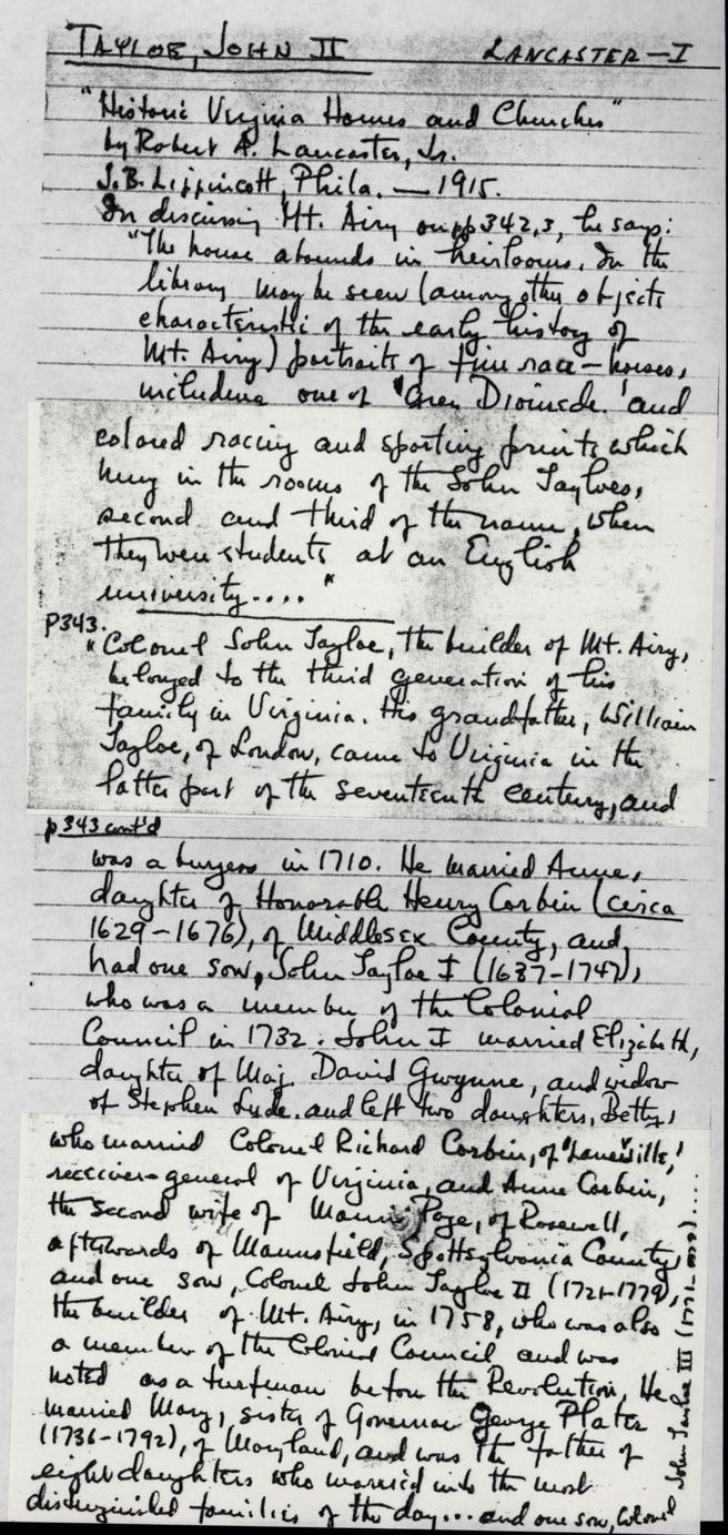
NOTES ON THE GRIFFIN FAMILY
An Obituary Notice of Dr. Samuel Stuart Griffin by his son, James L. C. Griffin:
"Dr. Samuel Stuart Griffin, M.D., was born in Philadelphia, Pa., on the 6th day of January 1782. He attended William and Mary under Bishop Madison ca. 1801-1802. In 1804-5 he was at the University of Edinburgh. Dr. Corbin Griffin, an uncle, and Samuel S. Griffin practised medicine in Yorktown. Later Dr. Samuel Griffin practised in Gloucester until his removal to Williamsburg in 1823. Dr. Griffin died on the 19th of December 1864, in Williamsburg, where, for about forty years he had discharged the duties of his benevolent profession with eminent ability. His remains were interred in the Cemetary of the Protestant Episcopal Church at Williamsburg, Va. No monument as yet. Dr. Griffin was married in Gloucester Town, Va., about the year 1808, to Miss Sally Lewis, daughter of James Lewis, Esq. and Mrs. Sarah Thruston Lewis …" (Copy from the "Diary of James L. C. Griffin (1866-1867)" 118 pages, Uncataloged Ms., Folder 123-B, William and Mary College)James Lewis Corbin Griffin:
"Died at Lansdowne, Gloucester County on Tuesday, October 22, 1878, Dr. James Lewis Corbin Griffin, son of Dr. Samuel Stuart Griffin, of Williamsburg, Va., and grandson of Judge Cyrus Griffin, the last President of the old Continental Congress, and who married Lady Christine Stuart, daughter of John, sixth Earl of Traquair, Peebleshire, Scotland.
"Dr. James Griffin was a graduate of William and Mary, and took his diploma at the University of Pennsylvania under Drs. Chapman and Horner, but never practised his profession. He was the last of his name; the Griffin family which came from Wales and settled in Lancaster county, Va., having descendants only in the female line; and for two years before his death he was the lineal heir of the above named Earldom of Traquair, now held by a distant relative of the Stuart family…"
(The Southern Churchman 7 November 1878, copy in William and Mary College Archives, Uncataloged Ms., Folder 123-B)
Illustration #3
| 1782-1800 | blank as to Tayloe family | |||
| 1801 | Littleton Tazewell . | l lot | $ 30 | |
| 1815 | Sarah Madison.r | 6 lots | $100 | Via Wm Tazewell and Maxy Page his wife a certain House & Lotts of Land in the City of Williamsburg and county of York on the North side of the Street leading from Palace Street to the Jail. |
| 1819 | Samuel Griffin | 7 lots | $130 | Via Ro G Scott--certain house and lot where the said Scott formerly resided and which was charged to Sarah Madison |
| *1820 | Samuel S. Griffin | 1 lot in fee | $1100 | value of lot |
| Gloucester | $1000 | sum added on account of buildings Formerly charged to Ro: G. Scott | ||
| 1828 | Samuel S. Griffin | 1 lot | $1100 | value of lot including buildings |
| Williamsburg | $1000 | value of buildings | ||
| 1 lot . : | $ 300 | value of lot Via Sidney Ferguson and charged heretofore to Joseph Ferguson's Estate | ||
| 1851 | Samuel S. Griffin | l lot | $1200 | value of lot including buildings |
| Williamsburg | $ 900 | value of buildings | ||
| 1 lot | $ 150 | value of lot | ||
| 1858 | Samuel S. Griffin | l lot | $3OOO | value of lot including buildings |
| $1800 | value of buildings | |||
| 1 lot . | $ 150 | value of lot | ||
| 1860 | S. S. Griffin | 1 lot | $3000 | value of lot including buildings |
| Williamsburg | $1800 | Value of buildings |
Illustration #4
ARCHITECTURAL NOTES
April 18, 1943
From: S. P. Moorehead
Re: Block 28, #3
Elizabeth Coleman House
West Outbuilding
Today I talked with Mr. George Coleman and his brother, Mr. Tucker Coleman about the small outbuilding west of the above noted building. They recalled it in detail as follows:
Basement
The basement was all open without divisions. Along the north wall were arranged
three horse stalls. The first floor framing was very heavy. There were two small
openings in the brick wall along the south wall which were filled with louvers.
In the west wall was a generous door opening.
The basement portion was of brick.
Kind of floor?
Were brick walls covered with plaster or wood?
What kind of door was used in the west?
First Floor
The first floor was divided into two rooms equal, or nearly equal
in size. A doorway led from one to the other in the middle of this partition.
There was a door in the east end served by a small flight of wood steps. There
were two windows on the south and two on the north walls. Some of the openings
had louvers. Some had sash, some had batten shutters. In the west end was a
loading door. The attic floor framing was very heavy and was exposed. The attic
floor boards were the typical Williamsburg Colonial kind showing adze marks on
the bottom with hewn sizing for proper fitting overjoists.
How was interior finished?
More information about windows.
What was west door like - how hinged?
What was inside door like - how hinged?
What was east door like - how hinged?
Use of first floor - room by room
Hardware.
Baseboard.
Ceiling.
Attic
The attic was used as a hay loft with a loading door in the west gable. This
door was a little over 5' high and opened in. At its head was a loading arm about 6 or
7' long and made of a 6"x8" piece of wood.
It extended well back into the attic roof framing and had an iron staple on the
exterior end. The attic roof framing was quite heavy, more so than usual. At
every third or fourth rafter pair was a tie creating A-trusses at these points.
This number was high enough from the attic floor to give good head
room. The roof pitch was about 45 degrees or more. There were no dormers on the
roof.
Was there a stair to the attic?
Now was hay gotten to the horses in the basement?
No dormers.
What kind of an iron staple - other hardware?
What kind of a door, batten?
Exterior
The basement was brick. From the first floor upwards the structure was of
frame. The outer sheathing was of very wide boards with beaded joints. There was
a simple cornice of crown, fascia, soffit and bed mold type.
Was boarding vertical or horizontal?
More information about windows.
E. Coleman
Other Outbuildings
[small map]
Notes 2 5 are shown in photos of Coleman collection SE corner of 2 and east elevation of 5
Mr. George Coleman and Mr. Tucker Coleman mentioned kitchen, torn down when George Coleman was about eight years old. They also mentioned a carriage house.
NOTES TAKEN BY MR. MOOREHEAD ON NOVEMBER 15, 1948, re TAYLOE PROPERTY
Yesterday I reviewed on the ground with Mr. Tucker Coleman what he remembered about the outbuildings of the above noted home when he was a boy.
Present Smoke House
Mr. Coleman said that the present smoke house is in its original location.
Well
Mr. Coleman recalled that the well is in its old location.
"Old Kitchen"
This building, no longer standing, stood just south of the present Smoke House and was far enough away from it to provide a good passage between the two. The "Old Kitchen" was 1-½ stories high with an "A" roof shingled in wood and without dormers. The gable of the roof ran east and west. What Mr. Coleman called the front was on the south towards Nicholson Street. The west end contained one window in the gable. He felt that there was no other opening in this elevation. The chimney was on the east end at the top of the present terrace slope but he could not recall whether this chimney was inside or outside the building.
A single room occupied the west portion of the first floor, the remaining space being devoted to room for two carriages-- one a phaeton and one a curry. This space was open to the South with no doors. Access to the space was from the south from Nicholson Street. The room at the west was entered from the carriage space. Mr. Coleman could not recall whether there was a window or door on the south wall of the room. A stair to the second floor or attic space was located at the west of the carriage space.
In the north wall of the carriage space there were windows. Beyond them was a pen for hogs which were fed through these windows.
Mr. Coleman said that this building was not used as a kitchen within his memory.
Old Foundations
East of the "Old Kitchen" Mr. Coleman remembered some old brick foundations located in the center (from east, to west) of the lower terrace. He recalled finding, as a boy, a box underground composed of flagstones, empty of any contents. He had hoped to find "buried treasures" and was accordingly greatly disappointed.